GIS Technology to assist in identifying "legal deserts"
December 6, 2023 -- NCSC has recently started utilizing Geographic Information Systems (GIS) mapping technology to assist state courts in identifying "legal deserts"- areas where people may face challenges accessing legal resources and services.
GIS technology can help courts gain deeper insights into the needs of people living in legal deserts by generating legal desert maps that consider access-to-justice risk factors such as the number of attorneys compared to the population, distance to a courthouse, poverty rates, limited English proficiency, and the absence of internet or broadband connectivity.
"We can integrate external data that we usually would not focus on, such as demographics, population characteristics, transportation routes, bus schedules, or public service provider locations," said Miriam Hamilton, an NCSC senior court research analyst. "This allows us to identify problems that were not clear before, set priorities based on locations with the greatest need, or even forecast trends."
NCSC Court Consulting Services Managing Director Danielle Hirsch expanded on Hamilton's comments by saying, "Sometimes internal court data is not enough to help identify the full problem, and GIS data can help us to see other solutions.”
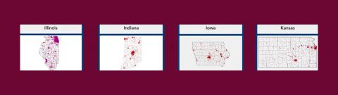
Hirsch recently shared some of these findings during a session at the CCJ/COSCA Midwest Summit. To date, NCSC has created legal desert maps for several states, including Illinois, Indiana, Iowa, Kansas, Michigan, Minnesota, Nebraska, Nevada, South Dakota, and Wisconsin. Additional states may be added in the future.
GIS analysis has revealed that legal deserts are not always found in rural areas. Urban areas can also experience risk factors and limited resources. Furthermore, GIS mapping can also address other court issues, such as finding solutions for high failure-to-appear rates.
One state that has embraced GIS mapping is Michigan, where courts are using data to guide activities for their Justice For All Commission, Michigan Legal Help program, and MI-Resolve, a free online dispute resolution system.
By expanding our view of data, NCSC is helping courts strategically use GIS mapping to layer and sort multidisciplinary data to reveal relationships and patterns in new ways to create relevant, actionable insights to better prepare courts for the future.
Learn more by exploring the Mapping Barriers to Accessing Legal Services data.
NCSC resource tracks mandatory judicial retirement age
NCSC has updated its report on State Judicial Retirement Plans to include a Mandatory Retirement Age tab, which tracks the mandatory retirement ages of judges across the country. In the last decade, voters and legislatures have rejected increases to mandatory judicial retirement ages in eight states.
NCSC now offers a data visualization map showing mandatory retirement ages.
The map categorizes retirement ages by court types (trial and appellate), provides links to state constitution or statute references, and includes special retirement notes where available.